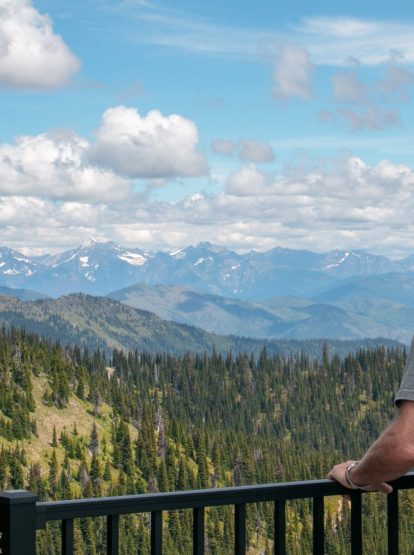
When it comes to scenic destinations for motorcycle riders, Kalispell, Montana is at the epicenter of them all. From Kalispell, the anchor of Montana’s Flathead Valley, motorcyclists can set out in a variety of directions to take in the scenic beauty that’s found around every curve in the road and awaiting at roadside pullouts. From Kalispell, riders can set out on day trip loop tours in a variety of directions.
Travel south around Flathead Lake via U.S. Highway 93 and north on Highway 35 to loop the lake. Or opt for a ride through the nearby Backbone of the World – Glacier National Park – and take in glacial-carved terrain and rushing waterways along the stunning Going-to-the-Sun Road. After a day of riding, explore Kalispell’s lively downtown, taste Montana ciders, wineries, beer and spirits and fill up on local culinary offerings before overnighting at one of the mountain town’s flagship or boutique hotels.
GOING-TO-THE-SUN ROAD, GLACIER NATIONAL PARK
For motorcycle riders, the Going-to-the-Sun Road is one of the most scenic routes to ride in the continental United States. Give yourself plenty of time to make the loop from Kalispell, while keeping in mind that there are plenty of opportunities to pull over and take in the landscapes.
Read more
Depart from Kalispell and head toward the park on U.S. Highway 2. Continue to follow U.S. Highway 2 north through Columbia Falls and into West Glacier, where you’ll turn left, ride under the overpass and cross the Middle Fork of the Flathead River before coming to the park’s entrance gate. From there, set out on the 52-mile-long Going-to-the-Sun Road as it crests the Continental Divide at Logan Pass. Suggested stops on the west side of the park include the Apgar Visitor Center (located just inside the park), Apgar Village and the southern end of Lake McDonald (where you can snap some stunning photos), and Trail of the Cedars.
Logan Pass – which sits at an elevation of 6,647 feet – provides views in every direction, as well as a visitor center, bathrooms and hiking trails. Keep your eyes peeled for mountain goats, bighorn sheep and bears. On the ride up, you’ll also ride past Bird Woman Falls and the Weeping Wall.
After a stop at Logan Pass, continue toward St. Mary (which is the east entrance to Glacier National Park’s Going-to-the-Sun Road) and soak in the wind-swept landscapes, which are starkly different from the west side of the park. Be sure to stop at the overlook to see Wild Goose Island on St. Mary Lake, which is one of the park’s most popular photography locations. Additional recommended stops include Jackson Glacier Overlook, Sunrift Gorge and the St. Mary Visitor Center.
Once you’re out of the park, turn right onto U.S. Highway 89 and continue west toward Montana 49 (Looking Glass Highway) and into East Glacier Park. From East Glacier, take a right back onto U.S. Highway 2 and ride along the southern border of Glacier National Park before returning to Kalispell. Recommended stops between St. Mary and Kalispell include Glacier Park Lodge in East Glacier Park, the Goat Lick Overlook near Essex and the Izaak Walton Inn.
Approximate distance: 201 miles. Approximate time: 5 hours

KALISPELL TO LIBBY LOOP
Travel north from Kalispell on U.S. Highway 93 through Whitefish and then on to Eureka, a charming town that sits in the lush Tobacco Valley just five minutes south of the Canadian border. After taking time to explore Eureka, follow MT Highway 37 to Koocanusa Bridge.
Read more
After crossing the bridge continue 29 miles on Yaak Valley Road East to the mountain town of Yaak, Montana. Drop by the Dirty Shame Saloon and the Yaak River Tavern & Mercantile before checking out Yaak Falls, a cascading waterfall in a narrow mountain valley. From here, you’ll ride along the Kootenai River through Troy and onto Kootenai Falls, which sits at milepost 21 between Troy and Libby. The falls are definitely worth a stop; be sure to give yourself enough time to take in the view of the falls, which are one of the largest free-flowing waterfalls in the northwest. A forested trail leads from the parking lot down to the Kootenai Falls Swinging Bridge. This area of Montana is considered sacred to the Kootenai Indians, whose ancestors inhabited the region. If this is your first visit to the area, some of the scenery may be familiar, as both scenes from The River Wild and The Revenant were filmed here. After visiting the falls, continue toward Libby on U.S. Highway 2 and return to Kalispell.
Approximate distance: 269 miles. Approximate time: 6 hours
KALISPELL TO LAKE KOOCANUSA
Head north from Kalispell on U.S. Highway 93 to Whitefish, where you’ll continue on to the charming town of Eureka. From Eureka, turn left onto state Route 37 to Lake Koocanusa. A 90-mile-long reservoir that sits behind Libby Dam, 50 miles of Lake Koocanusa are in the United States, while 40 miles are in Canada. Motorcyclists can ride on either side of the lake.
Read more
On the east side, continue on state Route 37 or head to the west side of the lake and ride the Lake Koocanusa Scenic Byway (Forest Development Road No. 228), which is a two-lane paved route.
Approximate distance: 235 miles. Approximate time: 4 hours, 30 minutes
Additional highlights include:
Kootenai Falls and Swinging Bridge

HUNGRY HORSE RESERVOIR
Located 20 miles northwest of Kalispell is one of the area’s most underrated destinations, Hungry Horse Reservoir. One of the largest concrete arch dams in the country, Hungry Horse Dam sits at 564 feet and is on the South Fork of the Flathead River.
Read more
From Kalispell, take U.S. Highway 2 north toward Glacier National Park. Once you arrive in Hungry Horse, turn right onto NF-895/West Side Road and follow it until you reach Hungry Horse Dam. From here, you can ride about 11 miles along the west side of the reservoir before the road turns into gravel. On your way back to Kalispell, switch up your drive by taking Route 206 and Route 35. Option: You can also continue down to Bigfork on U.S. Highway 35 and return on Route 82, where you’ll connect with Highway 93 before returning to Kalispell.
Approximate distance: 97 miles. Approximate time: 3 hours, 45 minutes

FLATHEAD LAKE LOOP
One of the most scenic drives, this loop takes you around Flathead Lake, which is the largest natural freshwater lake in the West. Along the way, you’ll travel through small towns, all of which are home to tasty restaurants, watering holes, museums, galleries and jaw-dropping views.
Read more
Start on the west side of the lake by traveling south on U.S. Highway 93. The southern half of the lake is on the Flathead Indian Reservation, which is home to the Confederated Salish and Kootenai Tribes. Be sure to stop by the Seli’š Ksanka Qlispe’ Dam (previously known as Kerr Dam) in Polson and take a walk down its 1,000-foot boardwalk for a spectacular view of the falls and the Mission Mountains in the background.
In Polson, take a left turn onto Highway 35 and start riding up the east side of the lake. This two-lane road hugs sections of the lake and gives you dramatic views of the shoreline, orchards and lake. Be sure to stop in Bigfork and stroll through its storybook-like downtown, check out local shops and grab a beverage before returning to Kalispell.
Approximate distance: 104 miles. Approximate time: 2 hours, 30 minutes

Resources:
Going-to-the-Sun Road Vehicle Reservation System